
Bay Area
New Weather Radar for Public Safety Response Part of Bay Area radar system, led by Sonoma, to be installed on Mount Barnabe
Extreme weather systems, such as atmospheric rivers, have hit California with increasing frequency in recent years. The average damage from floods caused by atmospheric rivers in California is now over $1 billion per year. Marin County has experienced its share of these intense storms and the damages are both costly and disruptive.
San Rafael, CA – Extreme weather systems, such as atmospheric rivers, have hit California with increasing frequency in recent years. The average damage from floods caused by atmospheric rivers in California is now over $1 billion per year. Marin County has experienced its share of these intense storms and the damages are both costly and disruptive. In times of emergency, accurate and timely forecasts are critical for cost-effective risk-based decisions regarding public safety response measures, infrastructure operations, and essential resource allocation.
The Marin County Department of Public Works (DPW) is collaborating with local, state and federal agencies, with Sonoma County Water Agency (SCWA) as the project manager, on weather radar installations at key locations across the greater San Francisco Bay Area. The result will be a regional weather prediction system that uses enhanced weather radar to track atmospheric rivers.
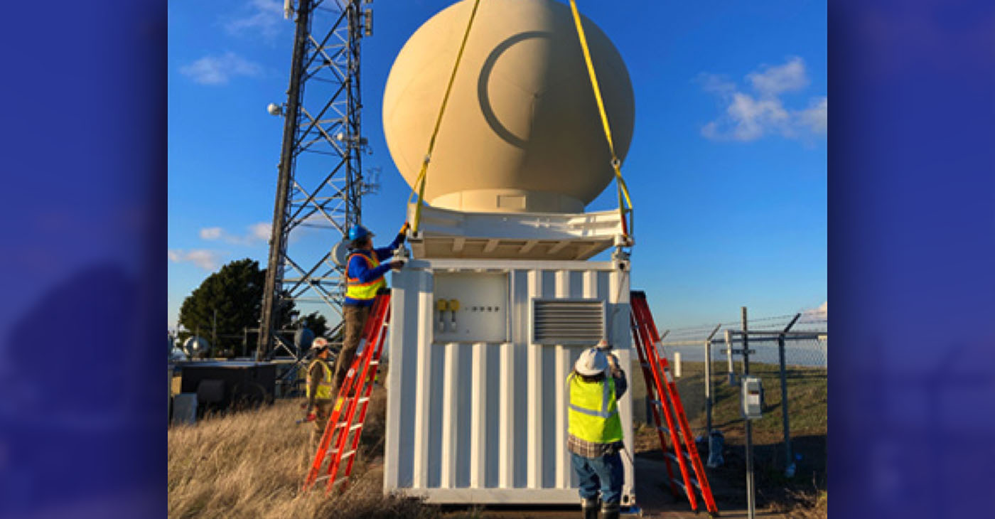
As part of a larger project managed by Sonoma County Water Agency, a new weather radar installation is expected to be installed on Mount Barnabe in West Marin, which will vastly improve emergency response and public safety measures for the entire Bay Area during atmospheric river events. The installation on Mount Barnabe would be similar to the one that was recently installed on Rocky Ridge in the East Bay (shown).
This public safety and emergency response improvement project is funded by grants from the California Department of Water Resources (DWR), California Office of Emergency Services (CalOES) and Federal Emergency Management Agency (FEMA).
The system, known as the Advanced Quantitative Precipitation Information (AQPI) project, includes two types of radar, X-band and C-band, which are being installed across various counties in the Bay Area. Five X-band radar installations will be placed in counties outside of Marin and a single C-band radar installation will be placed on top of County-owned Mount Barnabe in West Marin. The Mount Barnabe location currently has a MERA radio installation and a Marin County Fire Department lookout tower in proximity to the planned C-band radar installation, so electricity and internet connections are already in place.
An online community meeting was held February 15 to discuss the details of the project and answer questions for residents living in the vicinity of Mount Barnabe. The Marin County Board of Supervisors will consider SCWA’s proposed lease agreement for the Mount Barnabe site at the March 7 public meeting.
The C-band radar will be mounted about 10 feet above the ground on top of a 24-by-16-foot concrete pad. The 10-foot diameter golf ball shaped “radome” encloses and protects the radar antenna from the elements. To minimize visibility, the structure will be painted beige to better compliment the surrounding environment and blend in with the color tones of the hillside.
The C-band radar system uses a directional antenna to focus the beam in a specific direction, like how a lighthouse creates a narrow beam of light, and then scans vertically and horizontally to produce an image of the atmosphere. The radar will not exceed Federal Communications Commission (FCC) recommended radar levels for general population and is below all applicable regulatory standards. Also, because the radar will be placed 10 feet above the ground, the radar beam will be higher than the tallest person in the area.
Having a C-band radar on Mount Barnabe provides a clear view of the Pacific Ocean, which is where atmospheric rivers start. As storms hit land and move toward the Bay Area, the radar will track precipitation as it falls. The location on top of the mountain will also give great coverage of the populated areas of Marin. In Sonoma, Contra Costa, and San Mateo counties, the coverage of the new C-band radar installation will overlap with that of the X-band radars, giving all counties good coverage.
Both SCWA and the County of Marin have found the project to be exempt from the California Environmental Quality Act (CEQA) requirements for additional environmental review. The determination was made because the project is proposed on a previously developed area with similar government facility land uses, and the resulting radar installation would not impact the quality of the location, nor result in any cumulative adverse effects upon the surrounding environment.
Permitting is anticipated to be finalized by SCWA by mid-2023, with radar installation occurring in the second half of 2023. The timeline for the $2 million effort on Mount Barnabe is driven by the requirement that grant funding be used by the end of 2023. The operation of the radar system will be transferred to the Center for Western Weather and Water Extremes, which is part of the Scripps Institute of Oceanography at UC San Diego.


Activism
Oakland Post: Week of February 25 – March 3, 2026
The printed Weekly Edition of the Oakland Post: Week of – February 25 – March 3, 2026

To enlarge your view of this issue, use the slider, magnifying glass icon or full page icon in the lower right corner of the browser window.

Activism
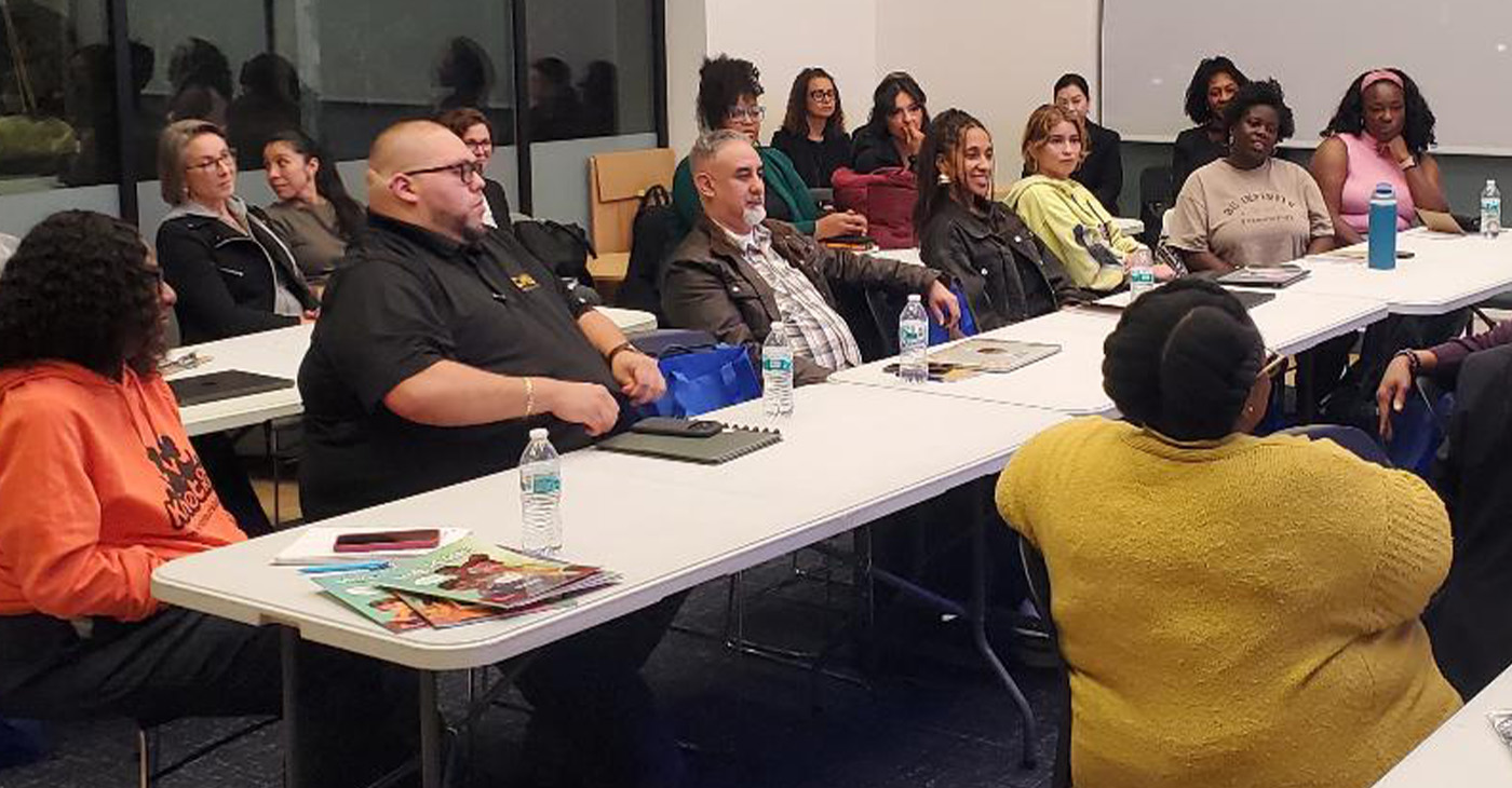
Chase Oakland Community Center Hosts Alley-Oop Accelerator Building Community and Opportunity for Bay Area Entrepreneurs
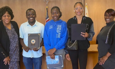
Over the past three years, the Alley-Oop Accelerator has helped more than 20 Bay Area businesses grow, connect, and gain meaningful exposure. The program combines hands-on training, mentorship, and community-building to help participants navigate the legal, financial, and marketing challenges of small business ownership.
By Carla Thomas
The Golden State Warriors and Chase bank hosted the third annual Alley-Oop Accelerator this month, an empowering eight-week program designed to help Bay Area entrepreneurs bring their visions for business to life.
The initiative kicked off on Feb. 12 at Chase’s Oakland Community Center on Broadway Street, welcoming 15 small business owners who joined a growing network of local innovators working to strengthen the region’s entrepreneurial ecosystem.
Over the past three years, the Alley-Oop Accelerator has helped more than 20 Bay Area businesses grow, connect, and gain meaningful exposure. The program combines hands-on training, mentorship, and community-building to help participants navigate the legal, financial, and marketing challenges of small business ownership.
At its core, the accelerator is designed to create an ecosystem of collaboration, where local entrepreneurs can learn from one another while accessing the resources of a global financial institution.
“This is our third year in a row working with the Golden State Warriors on the Alley-Oop Accelerator,” said Jaime Garcia, executive director of Chase’s Coaching for Impact team for the West Division. “We’ve already had 20-plus businesses graduate from the program, and we have 15 enrolled this year. The biggest thing about the program is really the community that’s built amongst the business owners — plus the exposure they’re able to get through Chase and the Golden State Warriors.”
According to Garcia, several graduates have gone on to receive vendor contracts with the Warriors and have gained broader recognition through collaborations with JPMorgan Chase.
“A lot of what Chase is trying to do,” Garcia added, “is bring businesses together because what they’ve asked for is an ecosystem, a network where they can connect, grow, and thrive organically.”
This year’s Alley-Oop Accelerator reflects that vision through its comprehensive curriculum and emphasis on practical learning. Participants explore the full spectrum of business essentials including financial management, marketing strategy, and legal compliance, while also preparing for real-world experiences such as pop-up market events.
Each entrepreneur benefits from one-on-one mentoring sessions through Chase’s Coaching for Impact program, which provides complimentary, personalized business consulting.
Garcia described the impact this hands-on approach has had on local small business owners. He recalled one candlemaker, who, after participating in the program, was invited to provide candles as gifts at Chase events.
“We were able to help give that business exposure,” he explained. “But then our team also worked with them on how to access capital to buy inventory and manage operations once those orders started coming in. It’s about preparation. When a hiccup happens, are you ready to handle it?”
The Coaching for Impact initiative, which launched in 2020 in just four cities, has since expanded to 46 nationwide.
“Every business is different,” Garcia said. “That’s why personal coaching matters so much. It’s life-changing.”
Participants in the 2026 program will each receive a $2,500 stipend, funding that Garcia said can make an outsized difference. “It’s amazing what some people can do with just $2,500,” he noted. “It sounds small, but it goes a long way when you have a plan for how to use it.”
For Chase and the Warriors, the Alley-Oop Accelerator represents more than an educational initiative, it’s a pathway to empowerment and economic inclusion. The program continues to foster lasting relationships among the entrepreneurs who, as Garcia put it, “build each other up” through shared growth and opportunity.
“Starting a business is never easy, but with the right support, it becomes possible, and even exhilarating,” said Oscar Lopez, the senior business consultant for Chase in Oakland.
Activism
Oakland Post: Week of February 18 – 24, 2026
The printed Weekly Edition of the Oakland Post: Week of – February 18 – 24, 2026
To enlarge your view of this issue, use the slider, magnifying glass icon or full page icon in the lower right corner of the browser window.


WORK FROM HOME
Home-based business with potential monthly income of $10K+ per month. A proven training system and website provided to maximize business effectiveness. Perfect job to earn side and primary income. Contact Lynne for more details: Lynne4npusa@gmail.com 800-334-0540
![]()

Poll Shows Support for Policies That Help Families Afford Child Care

Oakland Post: Week of February 25 – March 3, 2026

Trump’s MAGA Allies are Creating Executive Order Plan to Steal the 2026 Midterms

PRESS ROOM: NBA Hall of Fame Nominee Terry Cummings Joins 100 Black Men of DeKalb County to Launch Victory & Values Initiative

Reflecting on Black History Milestones in Birmingham AL

OP-ED: One Hundred Years of Black Workers Telling the Truth

PRESS ROOM: Civil Rights TV Launches in Selma as the World’s First 24/7 Civil Rights Television Network

Advancements in solar technology that are changing the way we power the world

U.S. manufacturing rebounds – how foundry services are adapting to rising demand

Why has blood testing become so popular in today’s world?

Ghana Mourns a Son of the African World

OP-ED: Trump’s Policies Hurt Black America—and Everyone Else

OP-ED: Meta Deleted Me. I Still Don’t Know Why. And neither will you.

More than a Mission: Paying It Forward for the Future of Education

Avoid Eviction This Season: Landlord Checklist for Stable Tenancies

Life Expectancy in Marin City, a Black Community, Is 15-17 Years Less than the Rest of Marin County

Oakland Post: Week of January 28, 2025 – February 3, 2026

Community Celebrates Turner Group Construction Company as Collins Drive Becomes Turner Group Drive

California Launches Study on Mileage Tax to Potentially Replace Gas Tax as Republicans Push Back

Discrimination in City Contracts

Oakland Post: Week of January 21 – 27, 2026

Book Review: Books on Black History and Black Life for Kids

Medi-Cal Cares for You and Your Baby Every Step of the Way

COMMENTARY: The Biases We Don’t See — Preventing AI-Driven Inequality in Health Care

Post Newspaper Invites NNPA to Join Nationwide Probate Reform Initiative

After Don Lemon’s Arrest, Black Officials Raise Concerns About Independent Black Media

OP-ED: The Dream Cannot be Realized Without Financial Freedom

COMMENTARY: The National Protest Must Be Accompanied with Our Votes

Black History Events in the East Bay

Art of the African Diaspora Celebrates Legacy and Community at Richmond Art Center

Hyundai Ioniq 5 Parking, Safety, and 360 View #shorts

2025 Ioniq 5 New Wiper & Powerful Performance! #shorts

Electric SUV Range: Is 259 Miles Enough? #shorts

EV Charging: How Fast Can You Charge an Electric Vehicle? #shorts

Biometric Cooling… Messaging Seats…Come on! 2025 Infiniti QX80 Autograph 4WD

Charged Up: Witness the Magic of a Fully Electric Car! #shorts

Range Rover Sport PHEV Included…: See What’s Inside This Luxury SUV! #shorts

Invisible Hood View: Perfect Parking with X-Ray Vision! #shorts

AI Is Reshaping Black Healthcare: Promise, Peril, and the Push for Improved Results in California

ESSAY: Technology and Medicine, a Primary Care Point of View

Sanctuary Cities

The RESISTANCE – FREEDOM NOW

STATE OF THE PEOPLE: Freddie

ECONOMIC BOYCOTT DAY!!!!!

I told You So
-
 Activism4 weeks ago
Life Expectancy in Marin City, a Black Community, Is 15-17 Years Less than the Rest of Marin County
-
 Activism4 weeks ago
Oakland Post: Week of January 28, 2025 – February 3, 2026
-
 Activism3 weeks ago
Community Celebrates Turner Group Construction Company as Collins Drive Becomes Turner Group Drive
-
 Business3 weeks ago
California Launches Study on Mileage Tax to Potentially Replace Gas Tax as Republicans Push Back
-
 Activism3 weeks ago
Discrimination in City Contracts
-
 Arts and Culture3 weeks ago
Book Review: Books on Black History and Black Life for Kids
-
 Activism4 weeks ago
Medi-Cal Cares for You and Your Baby Every Step of the Way
-
 Activism3 weeks ago
COMMENTARY: The Biases We Don’t See — Preventing AI-Driven Inequality in Health Care